Train Sim World 5
Cane Creek - Designing The Environment!
We catch up with Lewis from Skyhook Games and chat about how the spectacular environment of Cane Creek is being meticulously re-created for Train Sim World 2.
What do you do at Skyhook Games?
I’m Lewis McDonough and I’m an Environment artist at Skyhook Games, I take all of the art related tasks for a route. I’m involved in all of the art planning and do a lot of design and level work.
What has your involvement been like on this route?
Cane Creek has been enjoyable because I have been a part of this route since the start.
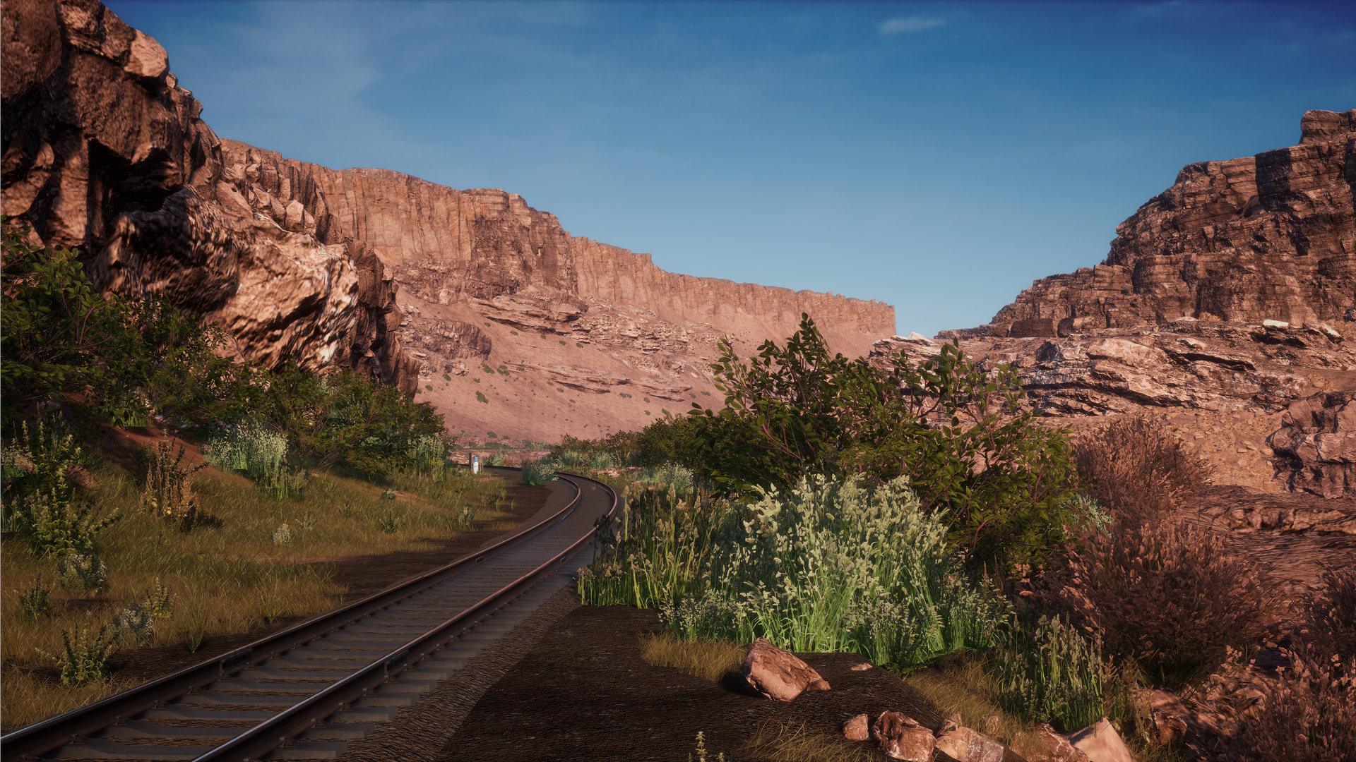
I began by blocking out the scenes and gathering reference, trying to breakdown areas we would need to focus on such as Potash where there are large canyons. I aim to break it down into it’s simplest form and determine what assets we were going to need.
Has it been challenging to get this route looking as accurate as you have?
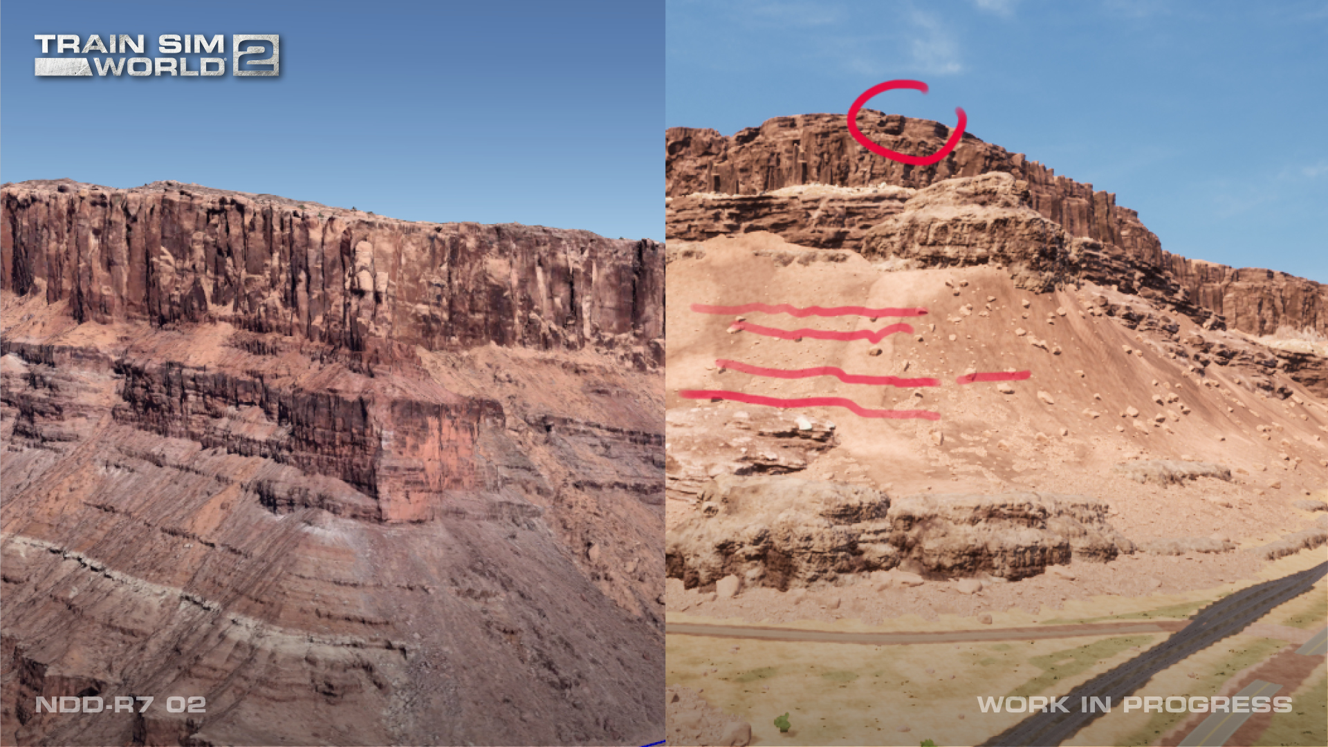
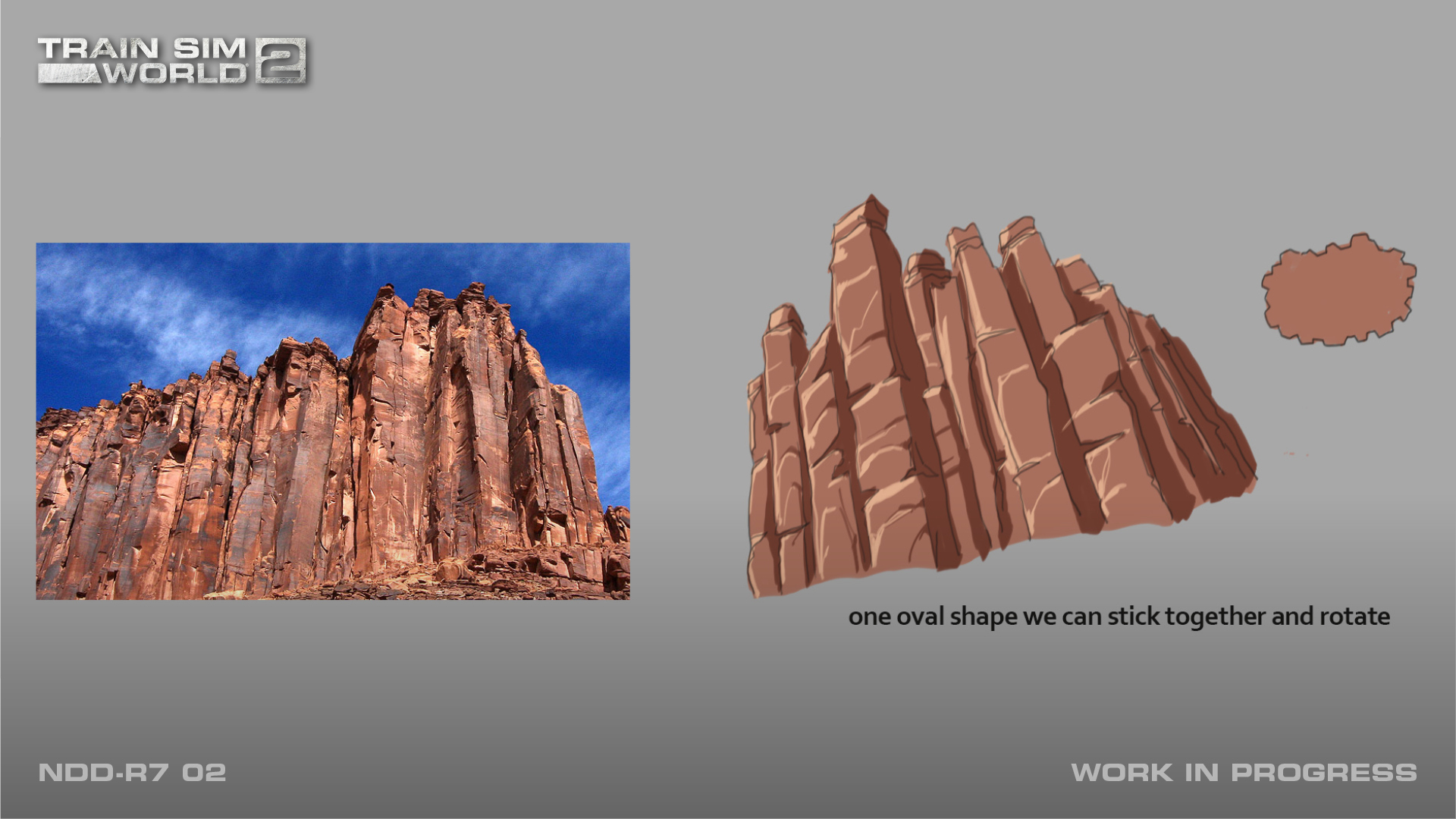
The Potash area and towards Moab where the main canyon areas are we spent a long time on at the start. We knew this was going to be the main feature for the route so we spent a lot of time getting reference and getting video. We tried to understand and break down the scale of the rocks.
Scaling was perhaps the most important part, they are so big that you don’t realise how big they are when you are looking at them. The scaling is strange, when you are there in real life they appear as though they are only 2 miles away but in actuality, they are 10 miles away.
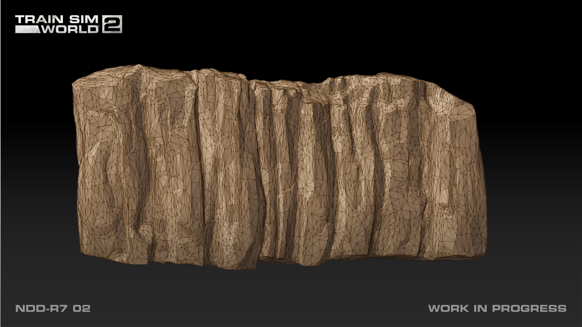
When we first started putting the assets in, they didn’t look right. We weren’t getting the correct detailing of the rocks.
It didn’t look right for a long time so we broke it down layer by layer to find out what it consisted of and how we can show it and make it run.

Was it a rewarding feeling once it started to come together?
It was weird for me because I was working on this one area for so long making small changes, and improving things bit by bit. Because I spent so much time looking at it, I didn’t notice it improving.
When I went to other artists and colleagues, they would comment on how much better it was looking, so it was really rewarding hearing it from them.

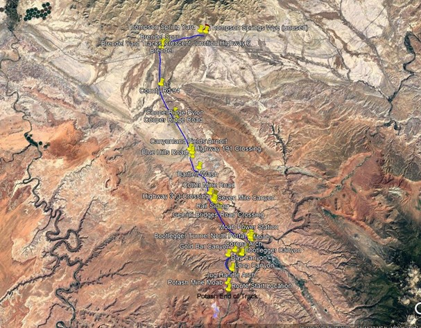
Where do you get your reference material from and how do you collect it?
Google Earth is usually the first place we will go to. With this being a popular area there is a lot of reference around, and it’s possible to drop in and have a look around.
We found loads of panorama pictures for the route as well. Having a 360° view is really helpful.
I will also watch some Youtube videos of people actually on the train, or people who have just visited the area. I try to collect as much imagery as possible.
It’s quite a time-consuming part of the project, but that’s when it really starts to feel exciting. We will see certain areas or certain rocks and think “oh I’ve got to do that, and make those canyons look good”. The challenge can be a bit intimidating at first but that’s what gets me enthusiastic.
Have you come across any challenges while creating Cane Creek? How does it compare to other projects you have worked on?
This has been completely different. I certainly didn’t anticipate how difficult the scaling would be. When reusing certain assets, it was hard to make them look as unique as possible. We used Quixel megascans, these are photo scanned assets which gave us a lot of detail.
Due of the types of rocks we were using they were scaled too small, and when we went to enlarge them to the correct size, the detail was relative to a smaller rock and so it looked wrong. We fixed this by using a lot of different rocks and techniques that were blended together.

What is something you are looking forward to the community seeing?
This will feel like a big change compared to other routes the community have driven, when you are driving as first person you really feel the scale of the canyons. You drive through what feels like corridors of the canyon.
My favourite part of this route is probably Mohab. There’s a tunnel for about a mile, obviously it’s really dark in the tunnel, but when you come out it opens up into this really detailed and open landscape.
There’s a bit of everything in that area, we have canyons either side, the water reflects the rocks which looks really good, and straddle carriers that take off shipping containers from different areas and locos. It’s lovely, especially during certain times of the day.
Have you come across anything unique with this route?
The colour palette. As artists we try to look at everything from a distance to get a sense of the whole picture. Does it read well? Does it sit well from a distance? In other routes there are traditionally very green palettes for trees and such.
Cane Creek however is a big change because we have very orange and red colours. It’s a contrast from the natural bushes which shows up really nicely.
Cane Creek is in development for Train Sim World 2, stay up to date on this route and more by following @trainsimworld on Twitter and Facebook

Images displayed in this article may depict content that is still in development. The licensed brands may not have been approved by their respective owner and some artwork may still be pending approval.
6
22
2
7
Train Sim World 5
4y
Cane Creek - Designing The Environment!
Train Sim World 5
3d
Class 86 - Release Date & Preview Streams
Train Sim World 5
4d
Providence/Stoughton Line HSP46 - Out Now!
Train Sim World 5
7d
Manchester Airport Commuter - Out Now!
Train Sim World 5
26 Jun
Steam Summer Sale - Now On!
Train Sim World 5
23 Jun
BR 194 / E94 Railtour Pack - Out Now!
Train Sim World 5
23 Jun
TSW5 – Post Release Patch 18 – Update Summary
Train Sim World 5
23 Jun
Köln - Aachen Timetable Update: Out Now!
Train Sim World 5
19 Jun
Manchester Airport Commuter - Coming Soon!
Train Sim World 5
10 Jun
BR 194 / E94 Railtour Pack – Coming Soon!
Train Sim World 5
10 Jun
Train Sim World 5 Roadmap - June 2025
Train Sim World 5
5 Jun
Cargo Line Vol.4: Military - Out Now!
Train Sim World 5
2 Jun
Train Sim World is coming to The Greatest Gathering.
Train Sim World 5
29 May
Thomas & Friends™ 80th Anniversary Expansion – Out Now!
Train Sim World 5
28 May
Cargo Line Vol.4 - Coming Soon!
Train Sim World 5
21 May
Join the Dovetail PlayLab – Help Shape the Future of Our Games
Train Sim World 5
19 May
Frankfurt S-Bahn: Out Now!
Train Sim World 5
13 May
Class 86/2 Loco Add-on: Coming Soon!
Train Sim World 5
8 May
Frankfurt S-Bahn: Coming Soon!
Train Sim World 5
6 May
Train Sim World 5 Roadmap - May 2025
Train Sim World 5
1 May
Cargo Line Vol.3 - Intermodal: Out Now
Train Sim World 5
15 Apr
Cargo Line Vol.3 - Intermodal: Coming Soon
Train Sim World 5
15 Apr
Train Sim World 5: Easter Event 2025
Train Sim World 5
3 Apr
ECML Diesel Railtour Pack - Out Now!
Train Sim World 5
1 Apr
Train Sim World 5 Roadmap - April 2025